





Once the fires began on January 7, stopping them was impossible. Hurricane-force winds and extreme dry conditions with single-digit humidity created a tsunami of flame, a towering wave of destruction that destroyed everything in its path and was carried for miles by wind-driven embers. The Palisades and Eaton wildfires weren’t the first and they won’t be the last, but they are among the most devastating in California history.
California’s unique ecology has evolved around fire, adapted to it. It’s not a new phenomenon—a 1999 study of charcoal samples retrieved from sediment cores collected in the Santa Barbara Channel found that weather-driven fires have occurred “more or less regularly” for the past 600 years—but climate change is rapidly intensifying the cycle of fire and flood. All the data points to wildfires becoming more frequent and more destructive as development encroaches on the wild land interface and the cycle of drought and floods becomes more extreme.
Anyone who stays for long in the Santa Monica Mountains must adapt to that pattern. We all know we will experience both if we stay long enough, but this January, hurricane-force winds propelled fire out of the mountains and deep into urban Los Angeles, destroying historic Altadena and the quiet neighborhoods of Pacific Palisades that were ablaze with pretty holiday lights just a week earlier. The disaster shook Los Angeles to the core, blanketing the entire basin in toxic smoke, displacing an estimated 180,000 evacuees, destroying more than 16,000 structures, many of them homes. It’s estimated that 14 percent of all dwellings within the perimeters of the Palisades and Eaton fires in the Los Angeles area have been damaged or destroyed.
That’s the thing that was different about this fire storm: it wasn’t limited to the mountains and the canyons: it burned right into the heart of fully urbanized neighborhoods that have never burned—friends in Altadena lost a house that was built in 1905 and their entire neighborhood. No one anticipated that a community like Altadena that had endured for over a hundred years would burn in a wildfire, not even after wildfires burned through towns in Lahaina, Hawaii in 2023 and the Napa Valley of California in 2020.
Five years ago, on November 8, 2018, a fire ignited near Southern California Edison equipment at the old Santa Susana Field Laboratory at the northern end of the San Fernando Valley. Driven by powerful Santa Ana winds, the fire took just six and a half hours to burn to the sea in Malibu, once it jumped the 101 in the early hours of November 9.
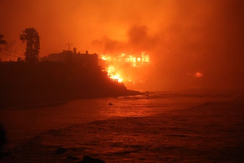
The Palisades fire moved even faster. It took just a few hours to spread from its ignition point near the Skull Rock trailhead on the Palisades’ side of Topanga State Park, to the sea at Sunset and Pacific Coast Highway. It also burned along the coast in both directions and up the canyons onto Sunset Mesa, Big Rock Mesa, Carbon Mesa and into Las Flores Canyon and the La Costa and Rambla neighborhoods in Malibu. The fire generated its own winds, spreading from the Palisades into Mandeville Canyon. Parts of Brentwood and even Santa Monica were placed under mandatory evacuation. The fire stopped before it reached the 405, not because of the almost superhuman efforts of firefighters but because the wind died down. Before that happened, there were plans to evacuate UCLA. Up at the Mulholland side of the fire, evacuations were ordered for parts of Encino and Woodland Hills, communities that have never before been at direct risk from wildfire, or at least, not since they were developed in the 1940s and ’50s.
On the western front, the month-old burn scar of the early December Franklin fire helped prevent the fire from surging into the Malibu Civic Center area and on into Western Malibu, but the fate of the Santa Monica Mountains and all of the communities in and adjacent to the range rested with the winds. If the Santa Ana’s hadn’t diminished the damage might have been even worse.
The Woolsey fire burned half of the Santa Monica Mountains National Recreation Area—nearly 100,000 acres. It also tore through parts of the Simi Hills and Santa Susana Mountains on its way to the ocean. The 101 freeway, which is a deadly and insurmountable barrier for wildlife, did nothing to stop the wind-driven fire from jumping across eight lanes of concrete. The damage the Woolsey Fire caused was widespread and devastating. It became the costliest wildfire disaster in Los Angeles County history. The fire spared Topanga, but only because an army of fire crews and air support took a stand at Malibu Canyon, and because the winds began to subside by the time the eastern flank of the fire reached Las Virgenes Road.
The Palisade’s fire was much smaller in area: 23,713 acres, but it burned through far more densely populated terrain. In some ways it was like a combination of the November 2, 1993 Old Topanga Fire, and the 1938 Topanga Fire. The 1993 fire burned through Old Canyon, racing to the sea at La Costa Beach. It burned 16,516 acres, 739 homes, and caused three deaths.
The Palisades fire burned many of the same properties in the La Costa and Rambla neighborhoods that burned in 1993, but it also crossed the highway to burn almost all of the beach houses from Topanga to Carbon Beach, it took out parts of Las Flores Canyon and most of the homes in Big Rock. It also destroyed an estimated eighty percent of the homes on Sunset Mesa, burning west into the Franklin fire burns car just east of the Malibu Pier, and as far east as Entrada Drive at the edge of Santa Monica.
The 1938 fire Topanga consumed 16,500 acres, burning a wide swath of what is now Topanga State Park and Pacific Palisades. Like the Palisades Fire, that blaze also burned houses on the beach, and it burned homes in what was then the newly founded community of Pacific Palisades that haven’t burned since, until now. Although the damage was extensive, neither of those previous fires were driven by 100-mph winds.
Wildfire is a growing problem worldwide. Communities in areas with high fire risk are increasingly vulnerable, and that includes the San Gabriel Mountains where the Eaton fire ignited, and the Santa Monica Mountains—the entire mountain range is designated a “very high fire hazard severity zone.” Now, it also includes communities anywhere near the mountains.
The Santa Monica Mountains are 52 miles from end to end and ten miles wide. This is a young mountain range—only about eight million years old—and it is still growing. The ruggedness and steepness of the terrain in the Santa Monica Mountains, the range’s east-west orientation, and the area’s Mediterranean climate—dry summers, unpredictable winter rain, and dense vegetation—create the perfect conditions for fire to spread once it ignites. The biggest and deepest canyons in the Santa Monica Mountains are oriented north-south and act like wind tunnels or chimney flues that channel the already hot and powerful Santa Ana winds in fall and early winter, increasing wind speed, sucking the moisture out of the vegetation, and transform tranquil canyons into unstoppable rivers of flame once a fire is sparked. The San Gabriels are older and much bigger, but they are also perfectly oriented to channel wind and flame.
Humans are almost always to blame when fire ignites. National Park Service data finds that 97 percent of the wildfires in the Santa Monica Mountains over the past hundred years have been caused by humans. The most frequent causes are arcing power lines and arson, but sparks from electrical equipment, power tools, campfires, cookstoves, vehicles, cigarette butts, and fireworks have all ignited fires.
The Santa Monica Mountains have experienced catastrophic wildfires in 1903 (the Malibu Rancho Fire); 1929, 1930 (the Potrero Fire, 8,783 acres; 1935 (the Latigo/Sherwood Fire, 35,000 acres); 1938 (the Topanga Fire, 16,500 acres); 1942 (the Las Flores Fire, 5,841 acres); 1943 (the Woodland Hills Fire, which burned in a long, narrow path from Topanga to Point Dume, 14,919 acres); 1956 (the Sherwood-Newton Fire, 26,000 acres, 100 homes, one death); 1958 (the Liberty Canyon Fire, 18,000 acres, 75 homes, 10 firefighters injured); 1970 (the Wright Fire, 28,000 acres, 403 homes, 10 deaths); 1973, 1978 (The Kanan Dume Fire, 25,000 acres, 230 homes, two deaths), 1982 (the Dayton Fire, 54,000 acres, 97 homes), 1985 (the Piuma Fire); 1993 (two fires on the same day: the Old Topanga/Malibu Fire 16,516 acres, 739 homes, three deaths, and the Green Meadows Fire at the Ventura end of the Santa Monica Mountains, 38,479 acres—this one burned to the sea at Leo Carrillo); 1996 (the Monte Nido Fire, 15,000 acres, two homes), 2007 (The Corral Fire, 4,720 acres, 53 homes, no deaths, but 14,000 people evacuated), 2005, the Topanga Fire, 24,175 acres in the Santa Susana and Santa Monica Mountains; 2013 (the Springs Fire (24,251 acres, 15 homes—this fire occurred in early May, a reminder that wildfire can happen at almost any time of the year); 2018 (the Woolsey Fire, nearly 100,000 acres, 1,600 houses, three fatalities. The 2024 Franklin Fire was only fully contained on December 19, just weeks before the Palisades fire. It burned 4,037 acres and destroyed 20 structures.
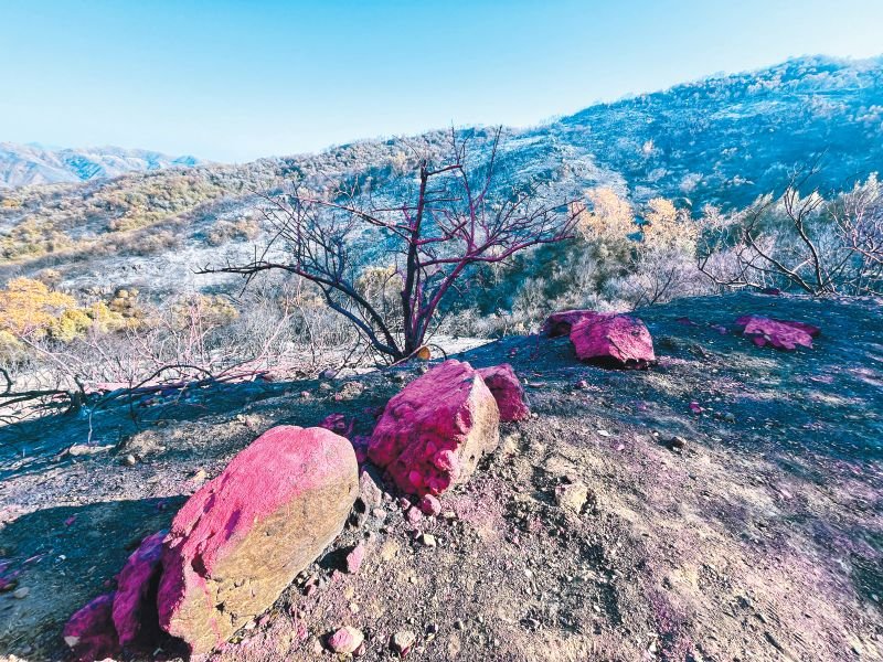
The nine-acre Lachman fire, which is thought to have been started by illegal fireworks just after midnight on New Year’s Day, may have been the incident that triggered the Palisades fire. The evidence suggests that a hot spot from the fire continued to smolder undetected, erupting to life on January 7, spreading on the wind. Lawsuits already filed allege that Southern California Edison equipment ignited the Eaton Fire.
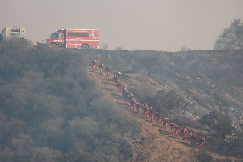
In between all of those major fire events are many smaller events that were stopped before they became disasters, usually because the Santa Ana winds weren’t blowing to fan them into monsters. For all of these fires, big and small, firefighters put their lives on the line to protect people and property. Air support is an amazing new tool, first used in the Santa Monica Mountains area during the 1982 Dayton fire, but the brunt of the fire containment work is still done on foot with hand tools like shovels, chainsaws, and bulldozers. It’s a dangerous and grueling job.
No one wants to think about the next major fire. It could come tomorrow, quite literally, or not for ten years, but it will come. Every part of the Santa Monica Mountains is at risk, but so are more urban areas, like Pacific Palisades and Altadena.. We have better tools now than they did in 1938 or 1993, or even 2018, but as the Palisades and Eaton fires demonstrated, there are no guarantees that all of those high tech fire fighting tools will be able to do more than give people time to flee.
For now, we are all in the process of cleaning up, digging out, coming to terms with death, and loss, and change. People live in Topanga, and Malibu and the Palisades and the foothills of the San Gabriels because they are beautiful places, special places, because they are home, but living here comes at a price—sometimes a very high one.

[…] exposure is real and well documented locally. The community’s own newspaper has reported that the entire Santa Monica Mountains range, which Topanga sits within, is designated a Very High Fire H…, a classification that shapes defensible space rules, brush clearance requirements, and […]