


Two years ago, fire came here.
It licked the thick brush from the high hills,
And filled the canyon with flame.
It leaped from the great parapet of Boney Mountain
And swept the slopes below.
The hill people fled before it.
They left the roads, arched with fire,
And followed the wild things
Seeking safety in the water courses.
The fire roared after
And did not pause in its ravening
Until it came to the sea’s edge.
Then the folk went back to the blackened smoking hills.
They had nothing left but their courage
And the stoic strength of the harsh land
Under their feet.
They had no assurance
Save the promise of the rain
And the surety of the seasons
To bring life back again.
They went back—
They belong to the hills.
—Madeleine Ruthven, “Mountain Fire,” 1934.
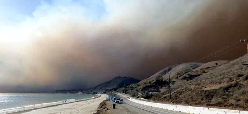
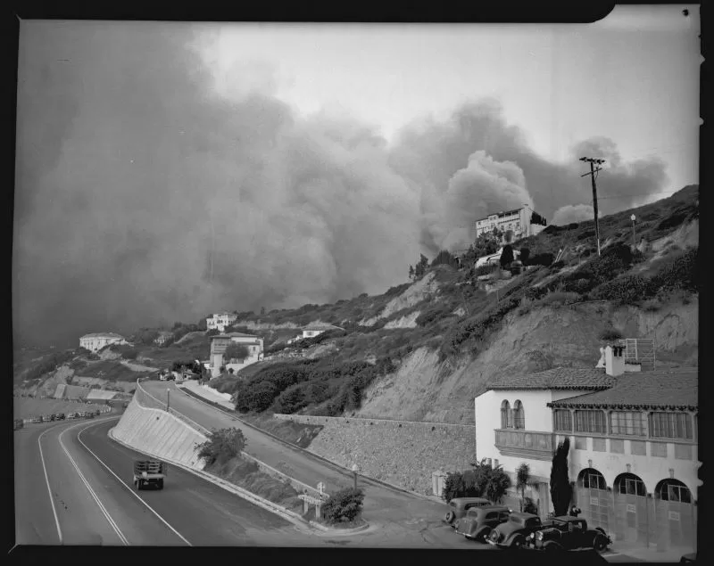
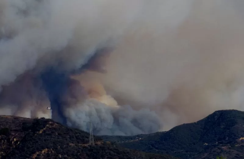
Five years ago, on November 8, 2018, a fire ignited near Southern California Edison equipment at the old Santa Susana Field Laboratory at the northern end of the San Fernando Valley. Driven by powerful Santa Ana winds, the fire took just six and a half hours to burn to the sea in Malibu, once it jumped the 101 in the early hours of November 9.
The Woolsey Fire burned half of the Santa Monica Mountains—nearly 100,000 acres. It also tore through parts of the Simi Hills and Santa Susana Mountains on its way to the ocean. The 101 freeway, which is a deadly and insurmountable barrier for wildlife, did nothing to stop the wind-driven fire from jumping across eight lanes of concrete. The damage the Woolsey Fire caused was widespread and devastating. It became the costliest wildfire disaster in Los Angeles County history. The fire spared Topanga, but only because an army of fire crews and air support took a stand at Malibu Canyon, and because the winds began to subside by the time the eastern flank of the fire reached Las Virgenes Road.
Thirty years ago, on November 2, 1993, the Old Topanga Fire burned through the canyon, racing to the sea at La Costa Beach. It burned 16,516 acres, 739 homes, and caused three deaths, leaving devastation and heartbreak in its wake.
Eighty-five years ago, the Topanga Fire consumed 16,500 acres, burning a wide swath of what is now Topanga State Park and Pacific Palisades.
Fire has shaped the landscape of California. All the data points to wildfires becoming more frequent and more destructive as development encroaches on the wild land interface and climate change accelerates, but it’s not a new phenomenon. A 1999 study of charcoal samples retrieved from sediment cores collected in the Santa Barbara Channel found that weather-driven fires have occurred “more or less regularly” for the past 600 years.
Wildfire is a growing problem worldwide. Communities in areas with high fire risk are increasingly vulnerable, and that includes the Santa Monica Mountains—the entire mountain range is designated a “very high fire hazard severity zone.” And that adverb “very” is warranted in this instance.
The Santa Monica Mountains are 52 miles from end to end and ten miles wide. This is a young mountain range—only about eight million years old—and it is still growing. The ruggedness and steepness of the terrain in the Santa Monica Mountains, the range’s east-west orientation, and the area’s Mediterranean climate—dry summers, unpredictable winter rain, and dense vegetation—create the perfect conditions for fire to spread once it ignites.
The biggest and deepest canyons in the Santa Monica Mountains are oriented north-south and act like wind tunnels or chimney flues that channel the already hot and powerful Santa Ana winds in fall and early winter, increasing wind speed, sucking the moisture out of the vegetation, and transform tranquil canyons into unstoppable rivers of flame once a fire is sparked.
Humans are almost always to blame when fire ignites. National Park Service data finds that 97 percent of the wildfires in the Santa Monica Mountains over the past hundred years have been caused by humans. The most frequent causes are arcing power lines and arson, but sparks from electrical equipment, power tools, campfires, cookstoves, cigarettes, and vehicles, have all ignited fires.
In between those major fire events are many smaller events that were stopped before they became disasters, or that occurred when the Santa Ana winds weren’t blowing to fan them into monsters.
Corral and Latigo canyons in Malibu have experienced the greatest number of burns over the past hundred years in the Santa Monica Mountains, but Topanga has also faced frequent fire. More than 25 wildfires are known to have burned through all or part of Topanga since 1925, when the County of Los Angeles Forester and Fire Warden first began keeping detailed records on the fire history of the Santa Monica Mountains.
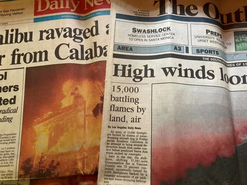
The Old Topanga Fire ignited on November 2, 1993, near a water tower above Old Topanga Road. The 911 call alerting emergency responders was made at 10:46 a.m. A Los Angeles County Fire Department First Alarm Brush response was dispatched at 10:49 a.m. Within the first half hour, the Incident Commander was already predicting that the fire would “go to the beach,” following the patterns of the 1956, 1970, and 1985 fires. It did. The western edge of the Old Topanga Fire swept through Las Flores Canyon and down into the La Costa neighborhood in Malibu. It burned almost all the way to Ramirez Canyon. The eastern flank of the fire, more than 15 miles away, burned up behind Fernwood in Topanga.
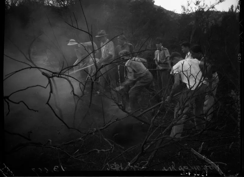
Topanga residents were forced to make the agonizing decision to go or to stay. Those who evacuated found themselves caught in a nightmarish traffic jam, one that mercifully resolved before the cars were overrun by flames. The people who stayed worked to put out fires, preventing embers from igniting and reigniting, saving their homes and their neighbors’ homes. Many families were forced to leave pets behind.
Three people died in the fire. One of them perished attempting to rescue a beloved cat. Many others were injured. The scale of the fire was so massive and the terrain so rugged it took nine days to fully contain the fire, and fire resources were stretched thin. A major fire broke out at the Ventura County side of the Santa Monica Mountains on the same day—the Green Meadow Fire, and there were devastating fires throughout the state that autumn, including the Laguna Fire in Orange county just days earlier. It burned 400 houses.
Even with limited mutual aid, air support helped to fight the Old Topanga Fire. That technology wasn’t available 50 years earlier, when coals from a stove at Trippet Ranch in Topanga ignited a fast moving fire at 12:49 p.m. on November 23, 1938.
The caretaker of Trippet Ranch sparked the fire by dumping a pile of ashes from the wood-burning stove out the door. Embers were carried into the brush by the Santa Ana wind. By the time the fire department received the alarm, the fire was “under great headway.” It burned all the way to Pacific Palisades, scorching 16,500 acres and destroying 350 structures, some of them at the beach.
R. J. Scott, the fire department’s chief engineer, wrote a full report on the fire. In 1938, the fire department had only hand crews and the most basic fire fighting engines and tenders better suited to house fires than wildfires. In his after action report, Scott laments that, “the Department depended largely on outside sources for caterpillars and bulldozers, this Department having only two which are dependable and we were obliged to avail ourselves of this equipment through the good offices of the County of Los Angeles, the Water and Power Department and by renting from private parties. This is very expensive equipment and rental charges are necessarily high. It is indispensable equipment, however, in certain fire fighting situations in the mountains.”
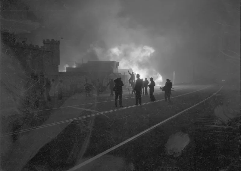
One thing the department did have was a phone line. That line turned out to be important, but not in the way intended. The line was down at Fire Department Lookout Station No. 3 at Temescal Peak on the day of the fire. Scott reported that the fire was called in by the member of the Bureau of Fire Alarm who had been sent to the station to repair the line.
A decade later, the Los Angeles County Fire Department was still campaigning for dedicated phone lines. Most lines in the Santa Monica Mountains were party lines that served multiple houses, including the local fire stations. Public service announcements printed in the local papers in the 1940s implore residents not to hog the phone. “Be willing to give up the line if a neighbor requests it to summon a doctor or for some other emergency.”
During the 1903 Malibu Rancho Fire, 120 years ago, there were no telephones, no fire engines, no bulldozers and only a handful of volunteer firefighters made up of ranch hands and homesteaders armed with shovels and burlap sacks soaked in water.
Things weren’t much better in 1956, when the Newton Fire roared through the mountains on Christmas Day. The fire, which broke out in Newton Canyon during 70-90 mph Santa Ana winds, charred 40,000 acres. Author William Clark Powell gives a vivid description of the fire in his book Ocian in View. Powell, who lived at Broad Beach in Malibu in the 1950s, describes how he and his wife and several neighbors, with the help of two Edison line crew workers, fought to save their homes from the firestorm, armed with shovels and garden hoses. They were fortunate. Many were not. 250 homes and structures were destroyed. Twenty years later, Powell’s home burned in the 1978 Kanan Fire, which followed the same path to the sea.
Even during the Woolsey Fire, with tools like cell phones, GPS and air support, communications failed early on, and those who chose to stay behind and fight to save their homes were on their own, with the same tools the Powells used sixty years earlier. Resources that might have been deployed for Woolsey were already allocated to other simultaneous disasters. The Hill Fire broke out near Camarillo at almost the same time as the Woolsey Fire—both fires started in Ventura County. An LA Times expose on the fires found that: “by 7:30 p.m. the Hill fire was being battled by 400 personnel while only 150 firefighters from three agencies were on the Woolsey fire, according to incident updates released by fire officials.”
The Hill Fire burned 4,381 acres and four structures, while the Woolsey Fire swelled to almost 100,000 acres. There weren’t enough resources to cover both fires, and many of the Ventura County emergency responders were already exhausted after having spent a gruesome and traumatic night at the scene of a mass shooting at the Borderland bar in Thousand Oaks that resulted in the death of 13, and injured 16. That disaster happened the night before the fires broke out.
Requests for helitankers and other mutual aid to battle the Woolsey Fire went unanswered. The helitankers had been deployed earlier that day to the Camp Fire, which also ignited on November 8, burning 153,336 acres, and killing 85 people in Paradise California, a community in many ways like Topanga. If all possible resources had been available, more houses might potentially have been saved, but it is unlikely that anything would have stopped this massive fire from reaching the sea—it was too big and too fast.
When the Palisades Fire ignited in May of 2021, it lacked the 90 mph winds that have fueled major wildfire incidents and it received full support from state-of-the art fire fighting aircraft, including helitankers. Topanga and Palisades residents benefited from the close proximity of the fully-functional helistop 69 Bravo, which enabled the aircraft to rapidly refill and return to the fire line in minutes. Even so, the fire spread to nearly 1,200 acres and took almost two weeks to fully contain. This fire is thought to have been set by an arsonist, but the hunt for the suspect was unsuccessful.
The next major fire? It could come tomorrow, or not for twenty years. Every part of the Santa Monica Mountains is at risk. Even highly urbanized Beverly Hills burned in 1961. We have better tools now than they did in 1938 or 1993, or even 2018, but when that fire does come, there are no guarantees that all of those high tech fire fighting tools will be here to help—other fires may take precedence.
Life in the very high severity fire zone is unpredictable. Often fire years are followed by floods and rock falls, as earth stripped bare by the fire turns into mud during the first post-fire rains. A five mile stretch of Pacific Coast Highway was buried under rocks and mud for weeks the winter after the 2013 Springs Fire. The Woolsey Fire destroyed critical infrastructure like culverts and guard rail on many canyon roads in the burn zone. Everyone should be ready for anything during peak fire season, and whenever the Santa Anas blow. Families should prepare and review evacuation plans, meeting points, and appoint an out of town contact who is willing to help take calls and coordinate if local cell service is down. Cell service failed almost at once during the Woolsey Fire and wasn’t restored in some areas for months, and coverage is still spotty in many parts of the burn zone.
Anyone who makes the choice to stay needs to be prepared for the worst. Making sure brush is cleared, gutters and roofs aren’t covered in dead leaves and that flammable items like lawn furniture are safely stored away from the house can make the difference between saving and losing a home.
The best advice is to evacuate sooner than later when a fire breaks out. Evacuation plans should include pets and larger animals. Families with horses, children, or elderly or disabled family members should plan to evacuate early. Getting horse trailers out of the canyon once fire crews are trying to get in is an almost impossible challenge. People who need oxygen or other support cannot count on having power or even water, and smoke from wildfires is a potentially deadly health hazard. Things can be replaced, lives cannot.
Why does anyone choose to live in a very high fire hazard zone? Perhaps because, like the homesteaders in Madeleine Ruthven’s poem “Mountain Fire,” we feel that we belong to the mountains, with all of their beauty and all of their challenges.


")